JIMBARAN
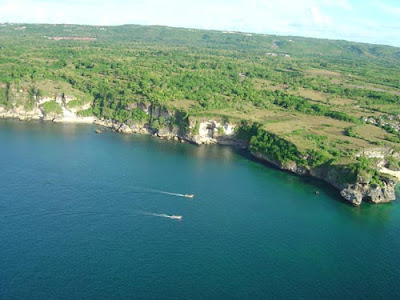
The first thing which strikes the visitor to Bukit Badung, the bulbous peninsula at Bali’s southermost tip, is that the landscape is totally different from the rest of the island. Most of Bali is volcanic — rich soils watered year- round by run-off from mountain lakes and streams, which support a lush, tropical vegetation. In contrast, the Bukit is a non-volcanic limestone plateau which has its own unique ecology.
The so-called “hill” — for that is what “Bukit” means — has an ecosystem characterized by its lack of surface water. The soil lies on a base of cracked and porous limestone, and any rain which does fall quickly seeps through fissures to a very low water table. The area is thus ill-suited to agriculture during the dry season, when the scrubby vegetation looks more Mediterranean than tropical. During the rainy season, however, the area’s vegetation becomes quite lush and crops of soybeans, sorghum, cashew nuts, maniooc, beans of various sorts and even corn, flourish.
The plateau which constitutes most of the peninsula rises abruptly to about 200 m above sea level, and is ringed on all sides by steep cliffs. It is connected to the rest of Bali by a narrow isthmus, upon which lies the village of Jimbaran. Many lovely beaches line the shores of the peninsula and the isthmus, although access is often difficult. The biggest and best-known beach is just beyond the airport, on the western side of the Jimbaran isthmus. More secluded and equally beautiful sands are found further to the south, at the foot of steep cliffs along the western and southern shores of the Bukit plateau.

Jimbaran as an administrative entity part of Kuta. and encompasses the area just of Bali’s international airport. Most of jimbaran’s 12,000 inhabitants live in a cluster of traditional battier neighborhoods at the narrowest part of the isthmus, but the Jimbaran area also includes the sparsely populated northest corner of the Bukit plateau and also including Uluwatu area. .


0 comments:
Post a Comment