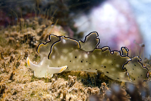
Located on the north western tip of Bali, Menjangan Island can be reached by boat from Labuhan Lalang port or from Terima Bay in Buleleng regency. It is received its name from the wild java deer that graze on its open savannahs. Menjangan Island is one of Bali’s premier scuba diving and snorkeling locales, this island has reefs that are frequented by species of fish of every size, shape and color. Menjangan Island boasts of 110 species of reefs and 226 species of reef’s fish and other kind of fish.
Menjangan Island has a good geographical position. With no current and wind-generate waves to contend with Menjangan Island is suitable for beginning and intermediate divers. And when it comes to visibility, Menjangan Island holds the sway, occasionally, the water can be crystal clear, and for the rest of the time visibility seldom go under 25 meters.

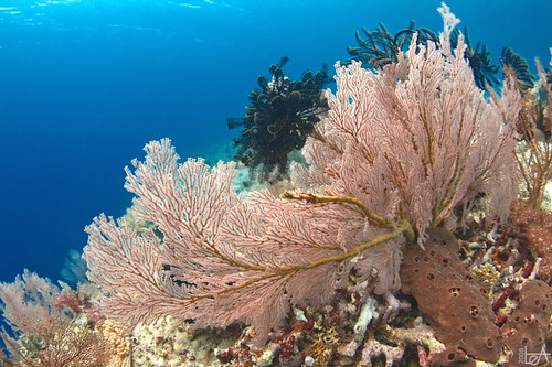
Under the water surface, Menjangan Island has variety of underwater terrain, from two meters below the surface to 150 meters offshore. The interesting feature which is offered by this island to the divers is soft coral walls around the island. The walls are almost vertical and extended down to 35-60 below the surface. The reef has unusually rugged surface with caves, grottoes, crevasses and funnel-like splits break up the coral wall, with nooks and crannies texture the surface of the walls. The walls are covered various large-size Gorgonians, huge-barrel sponges and soft corals.

On the south side of the island, divers can explore a spectacular 120-meter dropoffs and caves. On the north western end of Menjangan Island lies the “Anker” wreck, a 25-meter wreck lies on a sandy slope from 7 meters down to 45 meter underwater. This spot has excellent soft corals with variety of fish such as parrotfish, surgeonfish, unicornfish, butterflyfish, batfish, damselfish, triggerfish, scorpionfish, bannerfish and other reef life.
source:blog.baliwww.com